Sr Space Sys Engr | M' IEEE IET PEC | Project Mgr | Team Lead | Space Sys & Ground Ops Consultant | ICT R&D Advisor | Digital Twin SATCOM Trainer | EdTech Outreach | SpaceTech Writer

Space Empowerment
Empowering Academia and NewSpace with Insightful Innovative Space Systems Projects, SpaceTech Consultancy and accessible Space Outreach.


SpaceTech Skills
Systems Engineering
Leading trends analysis and strategic recommendations for early adoption of new space technologies.


Data Analysis/ Business Analytics
Turning data into actionable insights for real systems development and business startegies.


Projects & Operations Mangement
Managing unique Projects and day-to-day Operations both aligned with the mission and long-term objectives of the organization.
Projects Dissemination
Selected Projects Highlights


Numerical Calculations of Charging Threshold at GEO Altitudes With Two Temperature Non-Extensive Electrons
Surface charging at geosynchronous altitudes poses significant risks to spacecraft, often linked to extreme charging events during substorms. By employing a two-temperature q-non-extensive distribution function, we developed an improved current balance equation that better predicts charging thresholds compared to Maxwellian models, considering the effects of various non-extensive plasma parameters.


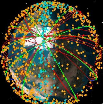
Air traffic monitoring using optimized ADS-B CubeSat constellation
Our study explores how CubeSats enhance Mega Constellations in Low Earth Orbit (LEO) for air traffic control and management. We present an optimized ADS-B CubeSat constellation designed to improve global air traffic surveillance, especially over oceans. By leveraging ADS-B technology, our solution offers cost-effective, comprehensive coverage for intercontinental flights.


Cost‐effective and novel regional navigation system using HEO/ GEO and GEO/ IGS Constellations
The research focuses on developing a cost-effective regional navigation system using two constellation models: Highly Elliptical Orbit/Geostationary Orbit (HEO/GEO) and Geostationary Orbit/Inclined Geosynchronous (GEO/IGS). The navigation link budget for both proposed constellations is theoretically calculated and verified, suggesting that HEO/GEO and GEO/IGS constellations could serve as viable alternatives to GPS.
A LEO Nano-Satellite Mission for the Detection of Lightning VHF Sferics (Space and Ground Segments)
A LEO nano-satellite detects VHF sferics from lightning, integrating a lightning antenna, receiver, and data acquisition in a compact design. A gravity gradient boom enhances sensitivity. The mission employs three identical satellites for global coverage, supported by a distributed ground network for real-time data tracking, analysis and dissemination globally.
Numerical Modelling and Rugged Techniques for De-orbiting of LEO Space Debris
We present a cost-effective approach to space debris mitigation using a Hoover Capturing System (HCS). By modeling debris clusters from events like Fengyun-1C and Iridium 33, and applying a magnetic field-based capture method, we offer a robust solution for removing millimeter and centimeter debris, ultimately burning fragments upon reentry.


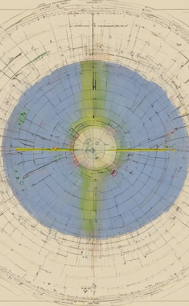
Sub-ionospheric VLF/LF waveguide variations related to magnitude M>5 earthquakes in the eastern Mediterranean area
This study investigates the variations in electric field amplitude of sub-ionospheric VLF/LF radio links related to earthquakes with a magnitude greater than 5 in the eastern Mediterranean area during 2022. By analyzing data from multiple transmitter-receiver paths, the research highlights the complex relationship between lithospheric events and waveguide variations, suggesting that multi-parametric observations could enhance the robustness of the findings.
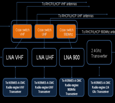
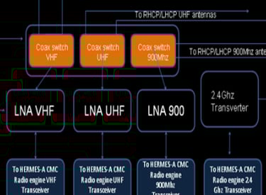
Internet-to-orbit gateway and virtual ground station: A tool for space research and scientific outreach
Internet-to-Orbit Gateway: The Ecuadorian Civilian Space Agency (EXA) has established an internet-to-orbit gateway (Hermes-A/Minotaur) that allows higher education students and researchers to communicate with the International Space Station (ISS) and access data from LEO/NOAA satellites.
Technical Capabilities: The gateway has a tracking range of 22,000 km and can receive signals from low-power satellite transmitters (∼0.1W).
Virtual Ground Station Design: The virtual ground station (VGS) is designed using free software suites, allowing multiple users to access satellite data without incurring high costs, thus promoting international collaboration in space research.
Training and Collaboration: Institutions like TU Graz-Austria, EXA-Ecuador and University of Michigan-USA, were involved in training students to operate satellites and process real-time data, preparing them for future missions with university-class nano-satellites.
Investigation of VLF/LF electric field variations related to mag Mw≥5.5 earthquakes in the Mediterranean region for the year 2023
The study focuses on earthquakes with a magnitude greater than 5 that occurred in 2022, specifically in regions crossed by sub-ionospheric narrowband VLF/LF radio links, including Italy, the Aegean area, and the Balkan Peninsula.
The research utilizes data from specific transmitters (TBB, ITS, and ICV) to a seismo-electromagnetic receiver facility (GRZ) in Graz, Austria, allowing for multiple simultaneous crossings of earthquake events.
The investigation analyzes electric field amplitude variations in the days surrounding the main shock, employing the night-time amplitude method with a temporal resolution of 1 second.
The study highlights the need for a certain threshold magnitude to achieve statistically significant results and suggests that multi-parametric observations within a network could enhance the robustness of findings related to the interplay between lithospheric events and electric field amplitude variations.


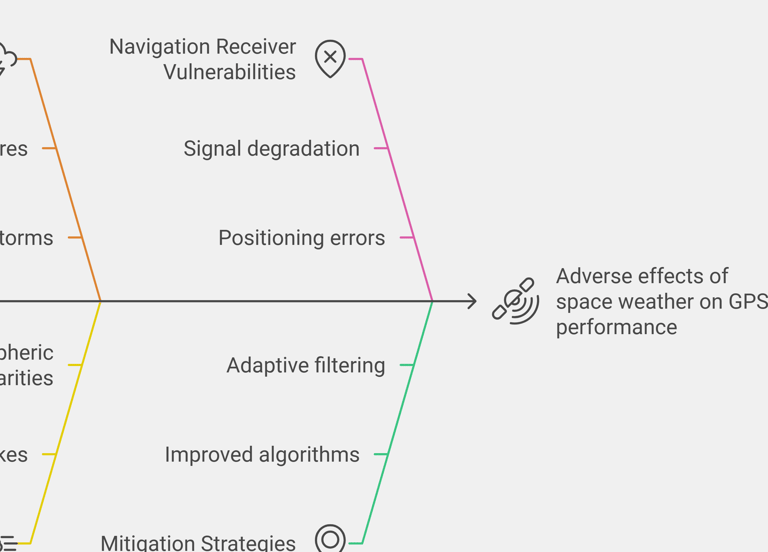
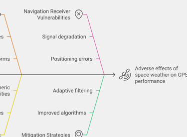
Investigating Space Weather Effects on Satellite-Based Navigation Systems
We present a design for a space-based ADS-B system comprising 20 LEO satellites to enhance global air traffic surveillance, particularly over trans-oceanic routes. The system offers improved accuracy and coverage, addressing limitations of existing radar and terrestrial ADS-B systems in monitoring congested airspace, with a feasible and cost-effective solution.
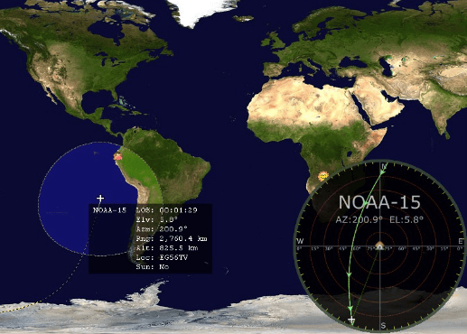
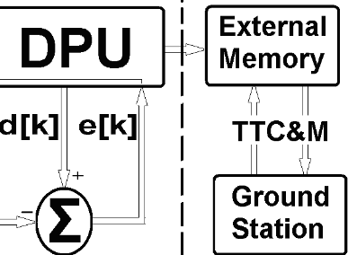
SDR based LEO Satellites' Ground Station Development, Ops, Data Analysis and RT (GUI) Dissemination
This project involves the development and operation of a ground station for Low Earth Orbit (LEO) satellites, utilizing Software-Defined Radio (SDR) technology. It focuses on real-time data collection, analysis, and dissemination through a graphical user interface (GUI), optimizing satellite communications and enhancing operational efficiency for LEO missions.
Projects
Another Perspective
